A little bit of exploration on the dunes lead to a discovery that surprised me, and some rudimentary amateur archeology!
Nosing around on the "Blornsh Bonks" we noticed some stonework and found an L shape structure. Strange place for a building, and why would only two walls survive?
What we hadn't spotted was another one, a short distance away, hidden by the greenery as we'd approached. Interesting, but time to go home.
Looking on the maps revealed that there used to be a rife range here. That explains it, the L shapes pointing downrange must have been safe refuges for the guys in charge of the targets.
Returning to the scene, grabbing a shot including both refuges and trying to figure out which direction to walk along looking to see if any of the numerous stones here might be distance markers.
Only on the way down did I notice this trench...
.. and even later I spotted the remains of the where the targets must have been, in the middle of the trench, halfway between the refuges. Time to see if any stones line up...
Yes! A 150 yards marker is easily found, slightly south of the path I originally took.
Another easy find, at 250 yards.
Nothing more found until 400 yards, and I'm making this a challenge for you to find, it's more satisfying that way :)
The 500 yards stone was half buried, and is facing the wrong way, and will also give you a challenge!
Nearly back at the car park, nothing else in the correct line was found until these, but...
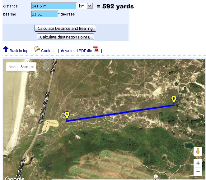
.. if this site can be believed
(it was correct within 3 or 4 yards for the other stones), this pair of stones is 592 yards away from the butts. Is this a 600 yards marker?
A zoomed out guide to where this all is. I enjoyed finding how much still exists and was quite surprised that the ground (sand) level hasn't changed in over 100 years, for the stones to still be visible and the butts to still be in clear sight along the line of markers (give or take a tree). The same applies to the WW1 POW camp remains to the north, not swallowed up by sand after all this time.
There are a number of other granite stones here, and some tipped over concrete foundations for WW2 posts of some sort I'm guessing.
As for the range, there isn't much information out there online, except that it ceased to be used in the early 1900s. The archive may be useful if you ask for C/A5/8
("surrender of lease on Blanches Banques rifle range") and C/A5/9
(rifle range at Blanches Banques with plan) amongst documents from 1895 to 1903.
You're going to go and look, aren't you? Enjoy your walk! (and do leave a comment if you appreciate my efforts, thanks, or give this a mention on FaceBook please)


3 comments:
Great pictures again, I love the long distance ones you don't really expect. I still check your page, just don't comment often.
Thank you Simon, really good to hear from you.
Clambering up some of the more inland slopes of the dunes, you can find areas of erosion absolutly littered with lead, mostly small-bore pancakes but also larger lead, 19th century stuff, right on the surface! So there must have been more impromptu targets set up over the centuries.
Post a Comment