Time to get out of the way some misc shots from the last few weeks... Grouville beach and common...
.. closer.
You don't see so many of these any more, so I thought I'd snap one for old times sake, while there's still one left (Rozel - also one at La Place).
Looks so lonely without anyone in costume around it :)
The joy of Jersey, you drive around a corner in a lane and suddenly a view like this presents itself.
The Dolmen Hougue des Geonnais - I can't help thinking it was a bit more open with less gorse around it last time I was there a few years back?
Having found a way down a farm track (or three) to the coastal path, a quick shot of the coast in the evening light...
.. Devil's Hole from a distance...
.. and the reservoir building at Mourier Valley (there's often a good waterfall here, when the water table permits, going over the cliff onto the pebble beach).
A tower in Grouville that's currently involved in plans to build a load of new homes around it.
The path from the slipway near the Seymour Inn, starts as it means to carry on, but then gets narrower and narrower with hedges intruding, and finally gets impossible so we have to climb down to beach level (tide permitting of course).
Eventually you end up on the beach for lack of a path, but you can nip back to the main road some way before Le Hurel Slip, using this footpath, to shorten a quick circular walk.
Originally, Oxford Road was a fairly long and winding affair, shown in yellow here... (Also in orangey colour, L'Avenue et Dolmen du Pré des Lumières and La Rue Le Masurier which are nearly 20 years young... they were created in the mid 1990s, the Coop Grande Marche was opened in Nov 2001, and the roads officially classified as Main Roads in 2002, La Rue Le Masurier now being part of the tortuous route of the circulatory systems of the ring road)...
... it cut through the middle of the Gas Place car parks. Now the new Town Park has done away with a stretch of it, leaving us with an absurd little stump of Oxford Road separated from the rest! Perhaps it could be more logically incorporated into Robin Place?
Still, at least it's not the shortest road in Jersey, which possibly goes to Le Passage Gosset by the museum - little more than a parking space!
While we're in the new park, here's the view towards David Place showing a path on what was part of Oxford Road...
.. and the other way, a view featuring what's left of the gas holder - for how long?
A park of tellytubby grassy knolls and some art installations. Definitely worth millions ;)
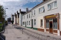
.. except for local businesses who found their customers can't get there easily any more. The cafe here is still going, but the hair salon closed. Note also the over-the-top expensive paving, only recently finished and already marked by tyre rubber. No expense spared, but give us a pavement way too wide and do away with even more parking :(
As if it wasn't bad enough, now it's sprouted some large signs!
Railings, railings, railings...
.. the spread of micromanagement and more and more bollards...
.. now making an utter eyesore of the Weighbridge!
Dear oh dear oh dear ... was the occasional parking there really so bad that this is better?!
Trust a private development to make their bollards interesting - this new batch at new offices on the old Swanson's site next to Payn St. (Esplanade to Seaton Place)... nicely varied and subtle... 10/10.
Pilgrimage
-
Every year around the time of the St Helier Fete, Sunday 20th July*, *there
is a pilgrimage to lay a wreath in the hermitage of St Helier, perched high
o...
6 months ago


2 comments:
Interesting set of photos, well done.
I never knew about the northern part of Oxford Road, that runs west to east, until a couple of weeks ago. It is strange how the road meanders from Tunnell Street to Byron Lane!
I totally agree, the new granite bollards at the Weighbridge are awful.
Keep it up, I really enjoy checking out your photos.
Thank you so much James, a good comment here and there makes it seem like I wasn't wasting my time :)
I will now go and find yet more stuff to point my lens at!
Post a Comment