Wednesday 29 January 2014

Resistance Nest Ville au Bas

This cluster of WWII bunkers got a mention on the recent page about the Civil Defence bunker in town. I couldn't resist a look around the area. These two half buried bunkers can be seen from the lane Cache de l'Eglise, but here we seen them from the other side - from what appears to be a footpath or bridleway which runs from the first bend in the track to Leoville MRC (gun club) and turns into a farm track emerging at the junction of Rue a l'Eau and Les Ruettes to the north.

The back of the larger bunker seen from the road.
Another, NW of the rifle club...
 .. and one south of that one, a hump in the field with an entrance like this.
Amongst the trees by the clubhouse, more bunkers, including this one down a ramp, with a broken fence and gate. Yes, this was the Civil Emergency Monitoring Post at St.Ouen.

There is also something concrete to see at the roadside in Rue de la Cour although it doesn't show up on Streetview.

If the footpath really is a public Right of Way, then it won't be unusual for people to be walking about here... enjoy!

Tuesday 28 January 2014

"Peat Forest" uncovered at St.Ouen's Bay

OK it's not headline news, having been covered in all the local media and with plenty of shots on Facebook, etc. But, seeing as I went to take a look, why not? The location is by a pair of steps near the fast food trailer at Le Port (map) near the end of Rte de la Marette.
As seen from the beach.
A layer of peat on top of looser material that some have called loess, but looks more like a cross between a newly started compost heap and Christmas pud to me :)
Looking down, 1....
.. 2.
You could probably arrange a crude joke about ancient wood and Bruce Forsyth if you're so inclined...
.. still quite impressive to think it's been here for some 8000 years. And still a little disappointing compared to what I've hoped to see ever since my parents (many years ago) said there were 'tree stumps' down here somewhere :)

Monday 27 January 2014

Tas de Geon guardhouse

On the trail of the old guardhouse at Tas de Geon. Tas = pile or heap, not to be confused with tasse = cup. Geon = Gorse/Furze (thanks Shane)

Here it is marked as a ruin already on a 1914 map.

Fighting through some gorse we found the spot. Note the grey spot where a pile of stones is found, and an oblong outline to the east - an old battery?
Don't expect to find this (1939 photo)...
.. just a rectangular dip in the ground, with some stone walls around 3 sides...
.. and a heap of stones to the north-east of the dip. That's the good thing about a nice day at this time of year, just wade through the dead bracken and brambles and you can get to spots that are too overgrown in the summer.
Les Hurets can be seen from here - at least that one is still standing.

So, not a lot to see here (although it might make for an interesting archaeological dig) but at least we can say we found what looks like the spot.

Friday 17 January 2014

Former Civil Defence Bunker at Springfield

This bunker was built by the occupying Germans in WWII as a repeater station for their telephone system. During the Cold War the Civil Defense Committee pressed this secure Vale Court facility (seen from Trinity Road on Streetview) into use for the purpose of collecting information about nearby nuclear strikes and radiation levels, sharing that intelligence with allied countries over a radio network. A fairly well equipped (for its time!) broadcasting studio allowed those in charge to keep the islanders informed about unfolding civil emergency developments.

The existence of this was denied and hushed up at the time, to the point that some people still confuse it with the JT building in Trinity Gardens; so my roving reporter reports that it felt a bit unreal to be able to look around at leisure! Contrary to rumour, this was not a refuge for all the VIPs of the day to live on while the rest of us perished (for that you may have to look elsewhere!), there simply wasn't the room or supplies and although the building was far more radiation-proof than a normal building it still wouldn't have qualified as completely safe. Just good enough to fulfill its role without all that much thought - as typical for the mad times - for the grim aftermath of nuclear conflict. Let's be grateful we have one fewer thing to worry about right now :)

Many thanks to my ever helpful source for these photos from the bunker's Open Day, it looks like a fascinating place. For even more information, you can download a PDF about it : jerseyheritage Civil Emergency CS Final Report pdf - get it while you can, and someone else's visit here is recorded at http://www.subbrit.org.uk/rsg/sites/j/Jersey_civil_e_c/index.html

First, a map to show where...
.. and a layout plan with the same alignment.
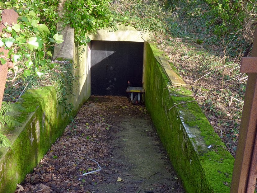
The outside.
Looking out, a nice chunky door.
Ahead, decommissioned warning sirens, and peeking around the partition...
.. dull but functional.
So, back to the entrance area, and looking right...
.. emerging into a reception area, with the Ops Room to the left...
.. looking back.
To the left of the doorway to the Ops Room. Before we go in, a look around the other spaces near the reception...
The Mess Room.
Bunks in the rest area currently used for storage.
Chilling to see a sign saying "Survivor Reception Centre"...
Handouts of the time, just paint your windows white to deflect the blast and you'll be fine cowering under the stairs ;)
That cooker looks like something from Wallace and Gromit's moon trip.
I've worked in places where this kind of kitchen would have been an improvement.
From the doorway, at the top of some steps, the main Operations Room...
..looking back. Behind the head-height padded screens...
a number of positions for radio operators...
.. in contact with Guernsey and France.
One for the scanner crowd, some obsolete old frequencies. Did you find all these? :)
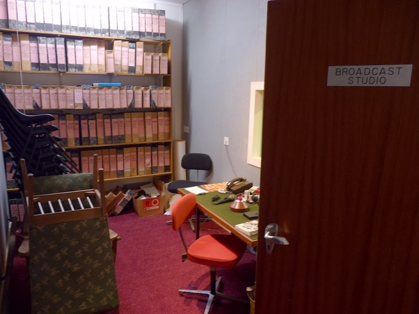
To the left of the studios entrance, a studio for the voice of calm to reassure us that we'll all be fine once the vomiting stops and there are no more teeth or hair to fall out.
Looking through the glass...
.. on the other side, where the knob-twiddler sits...
.. with analogue relics...
.. as if certain death wouldn't have been bad enough, just look at the audio torture we'd have been subjected to.
Connections to BBC Radio Jersey and CTV.
At the far end of the ops room, vintage PC equipment in the Met Room to track the weather and movement of radioactive fall-out clouds.
Somehow we coped with the threat of that lunatic horror looming over us.
A large map of the island. Plenty for budding historians to gaze at. WMO was the Warning and Monitoring Organisation that this was all part of - see also ROC Royal Observer Corps. Plenty to see too at UKWMO Communications.

The lines marked on the map are to the Airport, St.Ouen (Ville au Bas), Egypt (near Les Platons), Gorey, South Hill.

Here are the codes for Jersey's Monitoring Post Bunkers :
MP15 - Vale Court, Trinity Rd, St.Helier (map)
MP16 - La Moye, near ham radio club carpark (map)
MP17 - Ville au Bas - near St.Ouen's Church (map)
MP18 - Egypte (map)
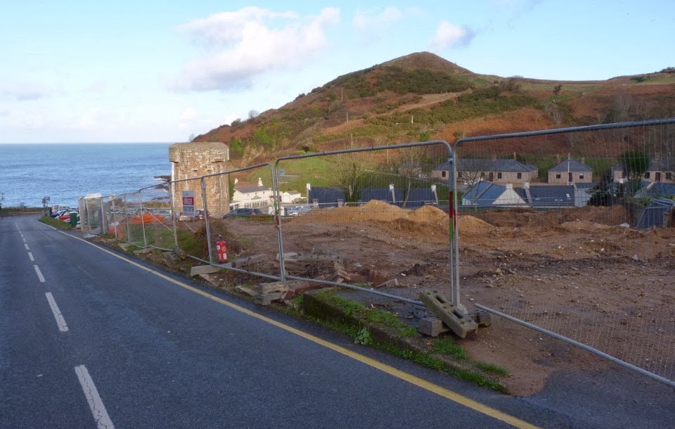
MP19 - Gorey - near Victoria Tower parking, a bunker overlooking the harbour currently festooned with aerials (map).

The bunker at Ville as Bas St.Ouen can be seen at subbrit.org.uk but it has changed a bit since those photos. You can still see the ramp beyond a broken fence and gate, and the concealed CCTV warning notice can probably be ignored, but the wooden fence has gone. The bunker is one of many around Leoville MRC (rifle club), others here being quite visible from the lane in the middle of fields, and some being mere lumps in the grass with telltale entrances. MP17 is along the track, amongst the trees just before the clubhouse. There is a bridle/foot path up northwards to Rue a l'Eau, so it can't be unusual to have people walking around. (UPDATE: I've since added a page for a look around the site)

Other locations marked on the map include :

Sirens
10 Grouville Hill
11 Gorey - Gouray Church on hill
12 St.Martin - School
13 Trinity - H.D. Farm
14 Five Oaks - Radio mast
16 Le Hocq - Mt Ube
17 Fort Regent Signal Station
20 St.Ouen - JT building opp. Farmers Inn
21 St.Lawrence - School
22 St.John - Parish Hall
23 St.Aubin - Hillside bunker above railway walk
24 St.Peter - School
25 La Moye
26 St.Ouen - St.George's
27 St.Mary - Parish Hall

? St.Brelade - Woodbine Corner
? Quennevais - Western Fire Station (pretty sure this was a siren)
? St.Helier - Rouge Bouillon School
? St.Clement - Samares School
? St.Ouen - Milano Bars site, L'Etacq
? Sion - opposite methodist chapel
? Grouville - near School
? St.Helier - Victoria College
? Rozel - Chateau.La Chaire Hotel

I remember hearing the siren tests many years ago, a haunting sound I'm glad I never had to really worry about. I hope this bunker relic from grim times is preserved as warning to future generations!

Return to bunkers index page

Wednesday 15 January 2014

Happy New Misc

At last Mount Bingham is open again after the rockfall. What a shame it now looks like an industrial area with the hideous fencing. In the past there was an attractive planted area here maintained by Parks and Gardens, and Beware of Falling Rocks signs to keep people away. And in all those years I never saw a single person there, and not once did I hear of any incidents or injuries. But now, even with the cliffs made safe, we have to put up with this eyesore! This used to be a "Wow Moment" for visitors, reaching the top of the hill from Havre des Pas and seeing the sweep of the bay, the castle and harbour (observe!) - but now it's blighted by the ugly fences each side, making it feel like a run-down urban area. How sad.

What's the point? Just exactly who is going to hang about there? And even if they did and were absurdly unlucky enough to be hit by a rock despite clear warning signs, would they really have a legal leg to stand on and sue?!

Did this new support structure have to reach right next to the roadside, making the corner so much worse than before for motorists?
Taking a break from the moaning, here's a snap from when we spotted something unusual at St.Aubin. Someone lost a bet and had to endure a forfeit :)
At Greve de Lecq, the hotel has gone, giving a view of the tower and old barracks from an angle not available before.
One for the conspiracy nuts to answer : how come all five of these aircraft ceased their long "chemtrails" all at the same time? Did they conspire to stop their chemical poisoning for now - or perhaps could it be just something to do with normal combustion exhaust vapour, temperature and humidity?! :)


So did Pontins burn down? No, it still looks much the same as it did before from this distance.
Closer... a bit singed, but still the same level of eyesore.
Road signs have been in the news lately. Here at L'Etacq are a pair of new signs without the incorrect preceding  "Le" definite article ahead of "Chemin". Pity they left out the much needed "La" from the middle of one :)
A perfect road for me to move to when I'm battling depression - a whole avenue of little sunshine!
The milk cartons have just gone a duller green. Still not as attractive as Guernsey Dairy's with their smart gingham check and elegant fonts on black panels.
"Ferguson's Folly" from the 1930s has been made over by the Parish of St.H - it used to be quite enclosed but is now more open...
... I can't help wondering if that's to stop the homeless from trying to sleep rough there now it's less of a shelter with the wind cutting through?
Changes in town... at #47 Halkett Place a former clothes shop has been taken on as a second outlet for Seedee Jons (who were previously only at the Powerhouse up at Queen's Road) after some 20 years of trading in various locations. They must think it's worth trying to flog their wares in town after...


.. the Blockbusters in Colomberie and Bath Street closed...
.. and HMV vanished from Voisins. It's now a clothing department, keep on going on a voyage of discovery through to the back of the shop and you emerge in the area that comes out in New Street with that sudden pleasant jolt of "aha, that's where we are!". That will probably bring a lot more footfall to what used to seem like a quiet backwater part of the store.


Blacks is the new Millets, for reasons only they (the same owners) could explain. Was Millets too naff and Blacks is more cool?
At #57 : Schuh has taken on what was NSEW, the one next to the pottery cafe, that had entrances in both King St and Broad St. Full of colourful Converses for the young and the not so young who are kidding themselves that they still are.

... and the other side of the travel agents is now Esprit.
Along the road next to the coffee shop on the corner with New St, at #45a the former Jessops is now Ecco.
Changes in Bond St - the old Bond's at #14 is now "The Niche" - more of a cafe bar than a grubby old all-day drinkers hangout. Next door at #15 (it's an oddly numbered street where the numbers go up by one along the west side from the Pier Road end and turn around at Conway street and come back along the east side) has been Emporio for a little while now, a coffee/sandwich shop. The card shop next door is awaiting something better than the dull grey patio slabs it used to have.

Sion Chapel, disused and about to be converted to housing. Some people say it's ugly but look at the magnificence of the scale and detail here! With tasteful painting it would be as attractive as this one, this one, this one, as the guys making the most of this one have found. I wonder how long this one has got?
Around the side of the Sion one, something about these two entrances looks appealing somehow - or is it just me?